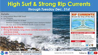
High Surf, Rough Seas, Will Hang Around A While Longer
Wednesday December 25, 2024

Update--Ventura, Santa Barbara, and San Luis Obispo counties have seen the high surf and rough seas peak Monday and Tuesday, but it's not over yet.
Although it will not be the 12-18 foot breakers experienced along Ventura County's coast earlier this week, or the 18-25 foot waves that hit the central coast, and the 8-12 feet seen along the south coast of Santa Barbara and Los Angeles County, higher than normal waves will continue through the end of December.
Expect 7-11 feet along Ventura County's coast with the highest near Ventura Harbor.
Wave heights along the central coast will range from 10-15 feet while the surf will range from 5-8 feet on Santa Barbara's south coast and in Los Angeles County.
Along with the high waves, expect rough seas and dangerous rip currents to continue for the next several days.
And all the same caution continues including stay out of the ocean and do not go out onto the jetties.
Boating is also not advisable.
A High Surf Advisory will be in effect from Malibu to Monterey.
A Small Craft Advisory will also be in effect for the inner and outer coastal waters from the Santa Barbara Channel to Santa Cruz.
And a Gale Warning is in effect for the outer coastal waters from the Channel Islands south and westward.
Below are all these advisories and warnings mentioned above...
San Luis Obispo County Beaches-
Santa Barbara County Central Coast Beaches-Ventura County Beaches-
728 PM PST Wed Dec 25 2024

...HIGH SURF ADVISORY REMAINS IN EFFECT UNTIL 4 PM PST SUNDAY...

* WHAT...Large breaking waves of 10 to 15 feet across the
  Central Coast beaches and 7 to 11 feet across the Ventura
  County beaches. Surf will be highest across west facing
  beaches. Strong and dangerous rip currents are expected.

* WHERE...San Luis Obispo County Beaches, Santa Barbara County
  Central Coast Beaches and Ventura County Beaches.

* WHEN...Until 4 PM PST Sunday.

* IMPACTS...There is an increased risk for ocean drowning. Rip
  currents can pull swimmers and surfers out to sea. Large
  breaking waves can cause injury, wash people off beaches and
  rocks, and capsize small boats near shore.

* ADDITIONAL DETAILS...Minor coastal flooding will be possible
  within a couple of hours of morning high tide, especially this
  weekend. High tides will increase from around 5 feet around 6
  AM PST to near 6 feet around 8 AM PST through this weekend
  into early next week. Shallow flooding of vulnerable beach
  roads, parking lots, and bike paths will be possible.

PRECAUTIONARY/PREPAREDNESS ACTIONS...

Remain out of the water due to dangerous surf conditions, or stay
near occupied lifeguard towers. Rock jetties can be deadly
locations in such conditions, so stay off the rocks.

***********************************
Point Piedras Blancas to Point Sal westward out to 10 NM-
Point Piedras Blancas to Point Sal from 10 to 60 NM-
Waters from Pt. Sal to Santa Cruz Island CA and westward 60 nm
including San Miguel and Santa Rosa Islands-
728 PM PST Wed Dec 25 2024

...SMALL CRAFT ADVISORY REMAINS IN EFFECT UNTIL 3 AM PST MONDAY...

* WHAT...Hazardous sea conditions.

* WHERE...Portions of the coastal waters of southwest California.

* WHEN...Until 3 AM PST Monday.

* IMPACTS...Conditions will be hazardous to small craft.

* ADDITIONAL DETAILS...See the Coastal Waters Forecast (CWFLOX)
  for more.

PRECAUTIONARY/PREPAREDNESS ACTIONS...

Inexperienced mariners, especially those operating smaller
vessels, should avoid navigating in hazardous conditions.
East Santa Barbara Channel from Pt. Conception to Pt. Mugu CA
including Santa Cruz Island-
728 PM PST Wed Dec 25 2024

...SMALL CRAFT ADVISORY REMAINS IN EFFECT UNTIL 3 AM PST FRIDAY...

* WHAT...Hazardous sea conditions.

* WHERE...East Santa Barbara Channel from Pt. Conception to Pt.
  Mugu CA including Santa Cruz Island.

* WHEN...Until 3 AM PST Friday.

* IMPACTS...Conditions will be hazardous to small craft.

* ADDITIONAL DETAILS...See the Coastal Waters Forecast (CWFLOX)
  for more.

PRECAUTIONARY/PREPAREDNESS ACTIONS...

Inexperienced mariners, especially those operating smaller
vessels, should avoid navigating in hazardous conditions.

*********************************
Outer waters from Santa Cruz Island to San Clemente Island to
60 NM offshore including San Nicolas and Santa Barbara Islands-
728 PM PST Wed Dec 25 2024

...GALE WARNING REMAINS IN EFFECT UNTIL 9 PM PST THURSDAY...

* WHAT...Northwest winds 20 to 30 kt with gusts up to 40 kt and
  combined seas 8 to 14 ft when conditions are worst.

* WHERE...Outer waters from Santa Cruz Island to San Clemente
  Island to 60 NM offshore including San Nicolas and Santa
  Barbara Islands.

* WHEN...Until 9 PM PST Thursday.

* IMPACTS...Strong winds will create dangerous sea conditions
  which could capsize or damage small and large vessels.

* ADDITIONAL DETAILS...See the Coastal Waters Forecast (CWFLOX)
  for more.

PRECAUTIONARY/PREPAREDNESS ACTIONS...

Mariners should alter plans to avoid these hazardous conditions.
Remain in port, seek safe harbor, alter course, and/or secure the
vessel for severe conditions.


